

Presenter(s)
Daniel P. Prince, ALmabrok Essa Essa, Sidike Paheding
Files
Download Project (500 KB)
Description
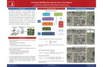
Unauthorized construction can cause damage to public and private infrastructure, including utilities, public housing, telecommunication equipment, etc. Current construction analysis is performed by human analysts, who can become fatigued after reviewing large amounts of imagery and are expensive to employ. In order to improve efficiency and reduce cost in monitoring this unauthorized construction, there is a need for automating the detection of regions of interest in imagery. In this work, we focus on the automatic detection of buildings. Sources of aerial and satellite imagery can be used as sources of data in order to perform these detections. While standard visible imagery with red, green, and blue channels may be used, additional information can be extracted through the use of infrared data. In this research, we have created a building detection algorithm that utilizes texture, shadow, road, and edge information for use in detecting buildings from visible and infrared imagery in rural, suburban, and urban areas. Several examples of real-world satellite imagery are used in order to evaluate our building detection algorithm.
Publication Date
4-9-2016
Project Designation
Graduate Research
Primary Advisor
Vijayan K. Asari
Primary Advisor's Department
Electrical and Computer Engineering
Keywords
Stander Symposium project
Recommended Citation
"Automatic Building Detection in Wide Area Imagery" (2016). Stander Symposium Projects. 803.
https://ecommons.udayton.edu/stander_posters/803
