

Presenter(s)
Sai Nikhil Reddy Mandhada
Files
Download Project (292 KB)
Description
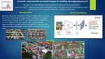
Extreme weather events impact large areas in a very short time, resulting in significant damages on many residential houses. After disasters, a recovery process should be promptly implemented to recover damaged local communities, but there are too many structures to be repaired with a limited number of resources. In the post disaster phase, detailed information—such as a degree of damage and house types—is required to automate disaster recovery planning and execution. However, previous studies have not investigated a method that can generate information with adequate details required to automate disaster recovery planning. To fill the knowledge gap, this study aims at recognizing building objects, detecting building damages, and measuring the extent of damage to individual building properties from aerial image data collected by drones. Semantic segmentation is employed to recognized buildings and their damages. The degree of damage will be assessed by a set of rules reflecting current manual assessment guidelines. This work is expected to help reduce a large portion of the current manual process in assessing the degree of damage for damaged buildings, thereby facilitating rapid disaster recovery.
Publication Date
4-22-2020
Project Designation
Graduate Research
Primary Advisor
Hongjo Kim, Van Tam Nguyen
Primary Advisor's Department
Computer Science
Keywords
Stander Symposium project, College of Arts and Sciences
United Nations Sustainable Development Goals
Sustainable Cities and Communities
Recommended Citation
"Semantic Segmentation on Aerial Images for Building Damage Assessment" (2020). Stander Symposium Projects. 1976.
https://ecommons.udayton.edu/stander_posters/1976
